
Test your knowledge of West Hartford history with this ‘Thursday Throwback,’ courtesy of the Noah Webster House and West Hartford Historical Society.
By Ronni Newton
It’s Throwback Thursday (#tbt), and time to take a look back into West Hartford’s past to either stir up some memories, reflect on how much things have changed, or both. And if you have no idea, we love the photo captions, too!
Courtesy of Town Manager Ron Van Winkle
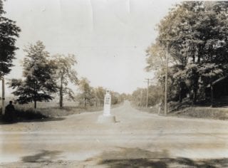
Last week’s photo (at right and in larger size below) inspired a lot of guessing – that is until some eagle-eyed readers, or readers with really good reading glasses, noticed the street sign in the corner of the photo. An enlarged version of that sign is provided below for those who did not, or could not, see it.
“Maybe New Britain Ave and South Main St. looking South. There appears to be a lady waiting for a bus and I think I see two children down the road. I would place this as the 30’s based on the lady’s hat (how’s that for slim evidence!),” was a great guess from Liz Gillette, who had not yet noticed the sign.
Other guesses, posted both as comments on the article and on Facebook, ranged from the intersection of Cottage Grove and Simsbury Road (not sure those intersect, and if they did it would be in Bloomfield, not West Hartford); Steele Road at the intersection of Asylum Avenue looking north; New Britain Avenue and South Quaker Lane; New Britain Avenue and Newington Road; Albany Avenue and North Main Street; and New Britain Avenue at Wolcott Street.

Close up view of street sign from Dec. 15, 2016 Throwback Thursday
Rick Liftig deserves a shout out because of his very thorough analysis. Here’s his comment in full: “Once again, Ron and Ronni have thrown us a tough one! The big clue is the signpost on the left (along with a shadowy figure) that says, “New Britain Avenue”. Well that narrows it down (and maybe not!). The shadows appear to be facing away from the viewer, so I am guessing this is a view to the North, It’s a major road too. The topography has me stumped as today’s NBA bears no resemblance to what is seen here. My guess is that this is the corner of South Main Street and NBA looking North where present day I-84 would be seen. Oh, and the date??? Well, there are modern telephone poles, NBA is paved, but the road in the picture is not. Survey says 1930.”
Rick and Liz were very close in their guesses about the year. The photo is dated June 30, 1926.

Courtesy Noah Webster House & West Hartford Historical Society
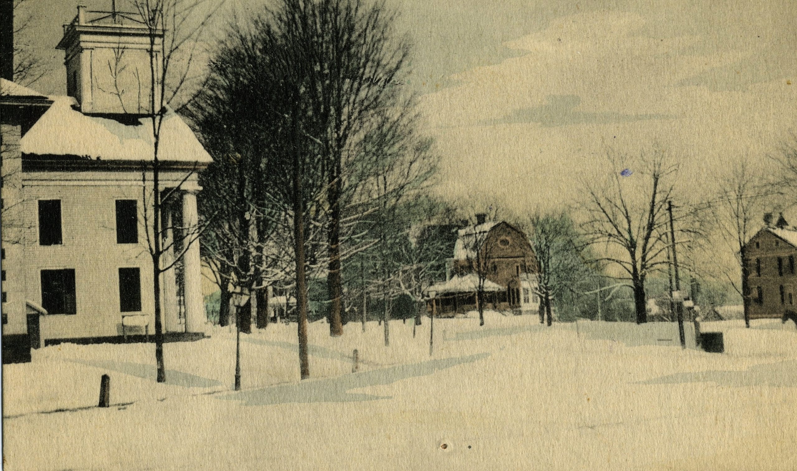
This week’s wintery scene (at right and in larger size below) is of another West Hartford intersection.
Who knows where this is?
When do you think this photo was taken?
What is in this location now?
Please share your memories below.
Thank you to the Noah Webster House & West Hartford Historical Society and Town Manager Ron Van Winkle for providing us with the images. They are always looking for new images to add to the collection. Visit their website at www.noahwebsterhouse.org for more information about membership and programs.
Like what you see here? Click here to subscribe to We-Ha’s newsletter so you’ll always be in the know about what’s happening in West Hartford!

Courtesy Noah Webster House & West Hartford Historical Society

Intersection of New Britain Avenue and South Main Street, looking north up South Main Street. in June 1926. Courtesy of Town Manager Ron Van Winkle


The corner of Farmington and North Main. The Congregational Church that became the Town Hall where the Veteran’s Memorial is now. While it seems to be looking north, I’m perplexed by the point of view, the angle. I’ll guess the late 20s or 30s. Does this show how we used to “roll”, or pack, the roads in the snow instead of plowing?