West Hartford Prepares for Possible Blizzard

Audio By Carbonatix

Photo credit: Ronni Newton (we-ha.com file photo)
The National Weather Service has issued a blizzard warning for the entire state of Connecticut beginning at 7 p.m. Monday, and West Hartford’s Department of Public Works is getting prepared the storm.

Photo credit: Ronni Newton
By Ronni Newton
The weather experts and forecast models may not be in perfect agreement, however it’s hard to find anyone predicting less than a foot of snow for West Hartford and the surrounding area.
Flakes are expected to begin falling as early as lunchtime Monday, and the National Weather Service has issued a blizzard warning beginning at 7 p.m. on Monday, Jan. 26., and lasting through 1 a.m. on Jan. 28. Forecasts estimate that snow will fall at a rate of 1 inch to as much as 4 inches per hour during the peak of the storm overnight Monday into Tuesday.
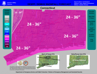
The snowfall forecast on this map (see below right) issued by the Department of Emergency Management and Public Protection and distributed by Gov. Dannel P. Malloy’s office on Sunday evening predicts a total storm snowfall of 24-36 inches for West Hartford and most of the rest of the state. The narrative the graphic Sunday evening said that some areas in central Connecticut may see as much as 40 inches.

That’s a heck of a lot of snow.
In addition, there’s the wind part of the blizzard warning. Officially, a blizzard warning is issued “when sustained winds or frequent gusts over 35 mph are expected with considerable falling and/or blowing and drifting snow. Visibilities will become poor with whiteout conditions at times.” Power outages (yikes!) are possible.
We-Ha.com asked NBC Connecticut meteoroligist Ryan Hanrahan to issue a specific forecast for West Hartford. Around 2 p.m. Sunday he replied with the following: “Right now it looks like 1-2 feet is possible in town. The worst will be Monday night and Tuesday morning. Wind gusts over 30 mph will result in some drifting as well. Too early to say if it will be historic or record-breaking, but all signs point to this being big.”
Hanrahan is trying not to over-hype this storm, which seemingly appeared out of nowhere over the weekend. He’s continuing to provide detailed predictions as well as the scientific background for his forecast on his blog. Click here for details.
West Hartford’s Department of Public Works had a very brief respite after working late on Saturday night cleaning up Friday’s storm, and came back to work Sunday morning for a combination of post-storm/pre-storm work. According to Director John Phillips, crews made sure that municipal and school parking lots, play areas, and sidewalks were ready for the work/school week, while the same time ensuring that open spots were available to put additional snow.
“DPW fleet maintenance will be working hard focusing on priority snow removal equipment to ensure the fleet is ready Monday night. I have had preliminary discussions with [West Hartford Police] Chief Gove on a strategy to tow vehicles that violate a parking ban. It important to have s strictly enforced parking bans for storms of this magnitude,” Phillips said Sunday night in email.
Phillips said that DPW staff will spend Monday morning making sure that all trucks are ready and in good repair for the plowing job ahead of them. They will attach tire chains and mount high discharge plow blades. Contractors will be called in earlier than normal to keep ahead of the storm, Phillips said.
“This was a strategy that work very well for Blizzard Charlotte [in 2013]. We have access to multiple large street snow blowers. The DPW team was advised to prepare for a multiple day event and to stock up on food and personal nourishments because we learned in 2013 that food markets, eateries and coffee shops are hard to come by,” said Phillips.
“A storm of this magnitude will have a significant impact on our community. Snow falling 2 -4 inches per hour is an incredible amount in a short period of time. We will not be able to keep up with snow fall rates as predicted. It could take a couple of days to totally clear and make safe all 218 miles of roads in town. Some neighborhoods could be snowed in for a prolonged period of time. Thirty to 40 inches of snow is a massive amount of snow to push. It will challenge us, test the limits and capabilities of our equipment. Residents should also remember that for every piece of equipment and plow truck there is a dedicated professional man or women doing their very best to meet the expectation of the community,” Phillips said.
Statewide, officials are also getting prepared. Gov. Malloy will hold a news briefing at 10 a.m. on Monday but has already ordered the State Emergency Operations Center (EOC) to be activated at 4 p.m on Monday.
“Based on the forecasts we’re looking at now and assessing the situation with state emergency management officials, I have directed the state’s EOC to be activated at 4 p.m. on Monday,” said Gov. Malloy in a news release Sunday evening. “We urge Connecticut residents to take necessary precautions. The state will continue to monitor, prepare and stay in front of this storm and react quickly.”
According to the news release, state emergency management personnel and representatives of the state’s utility companies will staff the Emergency Operations Center throughout the duration of the storm.
The American Red Cross has also issued winter storm preparation tips. Click here for details.
Who else will be at the grocery store tomorrow? Stay safe, West Hartford!
Like what you see here? Click here to subscribe to We-Ha’s newsletter so you’ll always be in the know about what’s happening in West Hartford!


