
From the West Hartford Archives: 1092R Farmington Avenue, House of Nelson G. Ford and Lena Smith

Audio By Carbonatix

1092R Farmington Avenue in 1909. Photo courtesy of Noah Webster House & West Hartford Historical Society
Historian Jeff Murray takes a look into West Hartford’s past to uncover some surprising information, stir up some memories, or reflect on how much life has changed – or hasn’t changed at all. Enjoy this week’s ‘From West Hartford’s Archives’ …
By Jeff Murray
This is a rare photograph of 1092R Farmington Avenue, across the street from Westland Avenue, in 1909.
In the West Hartford Historical Society archives, this is one of a few “unidentified” photos of houses in town in the year 1909. This was only recently identified as 1092R Farmington Avenue within the last year and it has helped uncover a bit more about the neighborhood between Staples Place and Pleasant Street. It once stood at street level, but was removed to the rear of the lot in the 2000s when condos were built. The house can no longer be seen very well from the road, but it has been preserved and its history can continue to be shared.

Current view of 1092R Farmington Avenue. Photo from Town of West Hartford property records
This area of Farmington Avenue was developed starting in the 1890s, originally with Pleasant Street, a bit east from the site of this house. As the population grew, more space was needed to bury the dead and the town voted to buy land for the new Fairview Cemetery from Charles M. Pond, who owned the 71 acre tract. Laid out in 1894, the cemetery could be reached by either Fern Street to the north, Whitman Avenue to the east, and a brand new road from Farmington Avenue to the south, known as Pleasant Street, in 1895.
Originally on the rear land of the Brace and Keeney families, the street opened up new building lots reached from Farmington Avenue, which launched a spate of real estate transactions and new houses for growing families. This was fueled by the electric trolley, which had been launched just a year before.
The owner of the land west of Pleasant Street to the current Staples Place was Theron H. Darling, a dairy farmer from Pennsylvania (and then Farmington). Darling married Ida Woodford in the 1870s and moved to the town in 1888. His farmhouse still stands at 1104 Farmington Avenue, four houses west of 1092.
His daughter Jennie married William T. Barto, a dentist who practiced in the Center. Another daughter, Blanche, lived across the street on Westland Avenue after that street was opened up in the early 1900s. Darling sold off some of the fringe lots around his property and then the rest of the 29-acre farm to Frederick Tucker in 1905.
One of the lots that Darling sold, however, was to a Nelson G. Ford in 1900 for a new house. Nelson Ford, an insurance agent, married a former middle school teacher Lena F. Smith on Oct. 3, 1900, so the house at 1092 Farmington Avenue, which was built by a Hartford builder Edgar F. Ede, was for the newlyweds. They moved in during the spring of 1902 after renting for a bit.
Ford’s father, Romulus, was a member of the Connecticut General Assembly during the Civil War, representing the town of Washington, Nelson’s birthplace. He entered the insurance business in 1886, joining the Connecticut Mutual Life Insurance Company, transferring over to their mortgage loan department a year later.
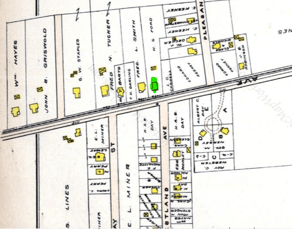
The house is included in this 1909 map of West Hartford (Photo Credit: 1909 Atlas, L.J. Richardson)
By the time of this photograph in 1909, there were several houses built along Farmington Avenue, but what is stunning is the glimpse of the open landscape behind, unobstructed, extending back before Wells Road was laid out.
Some notable land behind this house can be traced back to George B. Thayer when it was bought around the same time that Ford’s house was built. Thayer built a house in the grove in 1902 on the site of what is now the Church of St Peter Claver at 47 Pleasant Street, the corner of Whitman Avenue, across from the entrance to Fairview Cemetery. He had a unique career – he was a newspaper reporter, practicing lawyer, conducted several walking tours throughout the U.S. and Europe, and served as a YMCA worker in France after WWI (apparently he went over to the frontline in 1914 by himself as an observer and lived to tell the tale). He was well-known for his (insane) 1880s bicycle trip from Hartford to San Francisco and the book he wrote of his experience afterwards. He served in the Spanish-American War and was a physical education teacher to thousands of children at the West Hartford High School, the American School for the Deaf, and the YMCA.
He died in 1928 doing what he loved – walking – on the road returning from his son’s house in Putnam, Connecticut. Imagine walking to West Hartford from Rhode Island! One of his legacies beyond the achievements listed in his obituary though was the grove at the southwest corner of Whitman Avenue and Pleasant Street that he tended to. It was the site of many athletic and social gatherings. After attempting to gift the land extending back to Mountain Road to the town in 1917 (the town rejected it), he sold the property to William Mooney, who worked for Aetna.
The Mooney land therefore extended west from Pleasant Street all the way to around where Braeburn School is, and included the woods that bore the Mooney name in the decades following. The land in between that house and Nelson G. Ford’s house along Pleasant Street and Wells Road was filled in with new residences after WWI and into the 1930s as a prominent builder, Louis Slocum, capitalized on the development of Brace Road nearby. The Mooneys would eventually own both corners of Farmington Avenue and Pleasant Street, leading to the construction of the WWII apartment housing there today.
St. Peter Claver Parish purchased the property at the corner of Whitman Avenue in the mid-1960s and built a new church on the former Mooney estate. Fifteen years before, as a memorial to her late husband, William’s wife, Beula, donated nine acres of woodland to the town in 1953 – “Mooney’s Woods” was known to the children of the neighborhood for many years by that point.
Councilman P. Corbin Kohn said of the donation: “Mr. Mooney, whom they knew as a friend, gave them free access to the area and took pleasure in their enjoyment of it. In the woodlands, he himself sought relaxation from a municipality of business activities which took him all over the country.” One might say that the spirit of George Thayer had continued through the area. The landscape in the background of this 1909 photograph is a rare early view of this part of town.
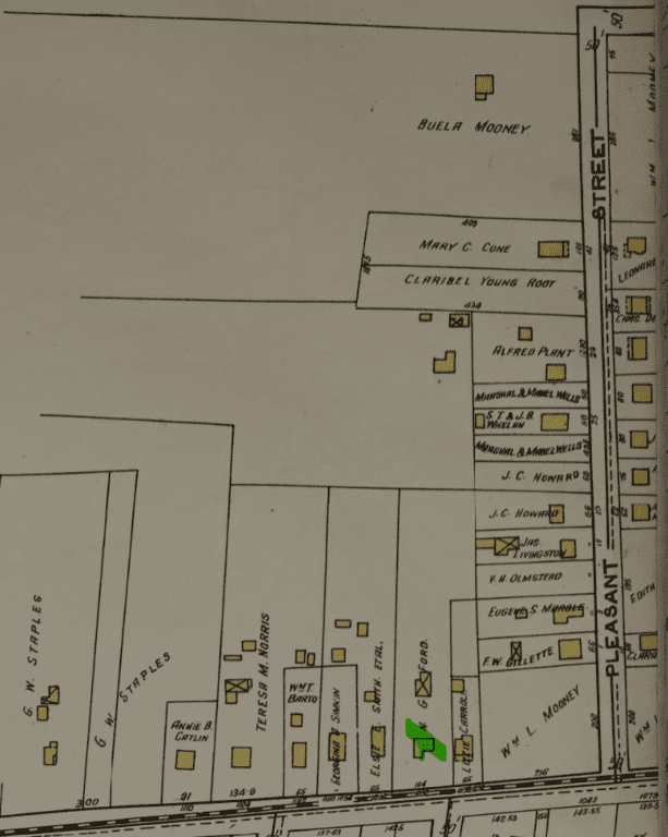
A map of the neighborhood, including the Mooney property at the top (Photo Credit: 1920 atlas, Sanborn Map Company)
Back to Nelson G. Ford, whose house started this research dive, he lived there with his wife until the 1930s. His two daughters and son married and left by the 1920s. By the time of his death at the house in February 1933, he had been with Phoenix for over 45 years. His wife sold the property then and lived for another quarter century on Riggs Avenue. Formerly a teacher, she was an amateur artist and author of historical articles on New Hampshire.
Old photos of houses are not just interesting snippets of a residence in the past; they are open doorways to the history of the entire neighborhood around it. From the time it was built in 1900, it was passed every hour by horse-drawn carriages, electric trolley cars, automobiles, and the tens of thousands who walked the length of Farmington Avenue over its many years.
But behind the photograph is also a reminder of the town it was taken in. The West Hartford of 1909 was not just riddled with the expected antiquated social attitudes of the day, but beyond the superficial headline of new houses popping up along the streets of neighborhoods like this one, it was also a town struggling with the speed of its own growth and its inability to keep up. There were tensions within religious institutions (including a violent brawl within one church), an exhausted and angry postal office, cramped and inadequate schools, lines of houses burned down in massive fires, overflowing sewage along major roads before sewers were built (1913), deaths from speeding automobiles, an immense tax scandal involving the collector, and more.
Old photos like this one are a glimpse into what the world looked like back then, but it’s also a reflection of the problems the local community had to overcome within itself. Maybe it’s also a clue on how we can overcome our own today.

1092R Farmington Ave can be seen in the center at the end of the driveway. Photo credit: Google Street View
Jeff Murray was born and raised in West Hartford and has been involved with the Noah Webster House & West Hartford Historical Society since 2011 when he was a high school student and won the Meyer Prize for his essay on local history. Jeff routinely volunteers as local history researcher uncovering information for numerous museum programs such as the West Hartford House Tour and West Hartford Hauntings. Jeff works as a data analyst at Pratt & Whitney.
Like what you see here? Click here to subscribe to We-Ha’s newsletter so you’ll always be in the know about what’s happening in West Hartford! Click the blue button below to become a supporter of We-Ha.com and our efforts to continue producing quality journalism.


Jeff, this is fascinating. Thanks so much for doing this research and sharing it with us. I live on Westland Avenue on the property that is overlayed with “Collinsville Savings Bank” on the map. Does that mean that the Burt family who built the house in 1901 borrowed money to do so? It’s clearly after the house and the barn were both built because they appear on the map. I’m also wondering where on Westland Blanche Darling lived? I used to live on Wells Road and love the area and appreciate you providing all of this interesting information!
Anne
Hi Anne,
Thanks! I think this is because the Collinsville Savings Bank foreclosed on Frederick N. Burt’s property at 51 Westland in the summer of 1908 to the summer of 1909. He owed $713.56 and was directed to pay the debt by August 1909 or title would pass to the bank. I don’t think it was that long, maybe the map is only a snapshot of the ownership at the time. The Burts owned it again by at least 1913, but lived at Buena Vista. I’ve had some difficulty parsing out a lot of the movements of families along Westland Ave because the addresses were renumbered about three times in just a few years early on, but it’s a work in progress!
Blanche Darling lived at what was then 22 Westland Ave, which is now 60 Westland. She went to Wellesley and taught out of town for a few years in the mid-1900s. She then taught at Bridgeport High School in 1907 for about 5-6 years, then taught French in Hartford in 1915 for 40 years. 60 Westland was built in 1916 for her and she lived there until the early 1960s. She died in 1966 and left four nieces.
I’d still like to figure out exactly what land holdings the Burts had because some of it is tied up with Frederick’s father-in-law Stuart Bishop. There is an immense wealth of information out there that someone probably put together on Westland, but interesting nonetheless! There is also a photo from the Courant in 1914 of Westland Ave looking north from the Boulevard, back when the area was being newly developed by the Lanman Realty Company.
Jeff, you are too much! I just devour every one of your articles. How you come up with this research is wonderful and breathes such life into the history. I too, always notice how ‘cleared’ the land was. If you squint and use your imagination it is clear that North and South Main St. are the “spine” of West Hartford. I would love your insight on the area between Fern and Albany – Main and Steel/Quaker, particularly the ‘bowl’ of the Saint Joe’s and UConn property. I remember the swamp as a kid growing up on Craigmoor and 2 lane Troutbrook flooding every time it rained. LOVE your articles!
Jeff, I was so excited to find this article. Nelson and Lena Smith Ford were my maternal great grandparents. Lena Smith Ford’s parents, Frederick Lewis and Elsie Locke Smith, lived next door. I have additional photos including the interior and rear of both homes, gardens, and the house next door to the Smith’s. I also see in the 1920 map a reference to the “Catlin” home. Nelson and Lena’s daughter Elsie married Wilfred Catlin. We currently own the Catlin’s summer home in NH (built in 1893). You helped me bring more of my family history together. Thank you! Please feel free to contact me.
Hi Melissa. I was so happy to find this article by Jeff and then to read your comment. My husband and I own this home now. We purchased it in November of 2019. We love this house so much and I’ve always been interested in seeing what it looked like in the past. I would love to connect with you to learn more and see old pictures – no pressure at all!