
From the West Hartford Archives: Trout Brook

Audio By Carbonatix

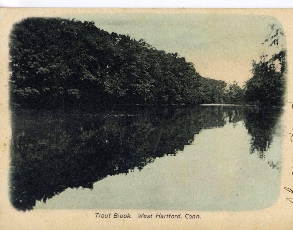
Trout Brook. Photo courtesy of Noah Webster House & West Hartford Historical Society
Historian Jeff Murray takes a look into West Hartford’s past to uncover some surprising information, stir up some memories, or reflect on how much life has changed – or hasn’t changed at all. Enjoy this week’s ‘From West Hartford’s Archives’ …
By Jeff Murray
Within the last two years, newer sections of West Hartford’s Trout Brook Trail have been opened north of Farmington Avenue to Duffield Drive, with future extensions in the works. The trail, which has been laid out in blocks since 2008 starting with the section from New Park Avenue to South Quaker Lane, has involved extensive funding and engineering work as part of the town’s vision for a greenway that is friendly to walkers and bicyclists.
The amount of time and effort that has gone into this project continues the long saga of West Hartford’s relationship with Trout Brook through the town’s history. Each branch of the brook has been a key ingredient in the town’s growth.
The western branches were used to flood the land for the Reservoirs to supply the town and the city of Hartford. The branch through the Center powered the mills and shops that clustered on Farmington Avenue, like the Trout Brook Ice Company’s pond. It was the ultimate energy behind West Hartford’s first settlement in 1679 when Stephen Hosmer built a sawmill on North Main Street between Wyndwood Road and Brookside Boulevard. Later, it was the source of the Trout Brook Ice Company’s secondary operations. Wood Pond and Woodridge Lake were created just over a hundred years ago using the brook that split through Buena Vista. It had outlets in the northwest section of town too, powering the Highland Creamery at Albany Avenue and Mountain Road or the Talcott Mountain turnpike. The southern branch that leads to South Quaker Lane and weaves through Elmwood helped fuel the rise of industry there.
West Hartford’s history is dotted with old mills stationed along strategic points of Trout Brook that no longer exist, like the Talcott woolen mill near South Quaker Lane.
Just as much as the brook was a friend of the residents here, it could often become an enemy very quickly. A dam break at the Reservoir in 1867 destroyed a significant number of buildings and successive floods (most notably from hurricanes in 1955) were a constant reminder of just how prominent Trout Brook was in West Hartford. It prompted years of intense flood control measures where the flooding was the worst. It was also a vessel for disease and filth that could easily seep into the common water supply as well as household ice supply when it was harvested from the pond in the Center.
By day, it was used to create skating ponds in the winter, bathe brick laborers, and cool off school children in the summer. Overnight, it could turn up bodies from accidental drownings and suicides. If a family member went missing, Trout Brook was a convenient and ominous culprit.
It is obvious that for hundreds of years, Trout Brook was merely a source of water to be used or altered to use, rather than a natural landmark to be conserved or duly appreciated. The first seeds of this idea though were planted in 1914 when some residents led by the town’s public improvement committee proposed a parkway or a series of parks that would trace along the brook from Bloomfield to Elmwood.
The emphasis on a road that could allow people to simply enjoy the brook as a natural beauty was a reflection of a national movement known as Progressivism. The Progressive Era in the United States was born out of industrialization and the rise of urban society, which saw labor and ethnic conflicts, corrupt city governments, unregulated business, and unprecedented poverty. Progressives from the 1890s until World War I demanded that the government step up to limit the excesses of capitalism and help unify a fractured world.
Trout Brook. Courtesy of Noah Webster House & West Hartford Historical Society
One of the ways that this manifested was the conservation of nature. Some Progressives, like President Theodore Roosevelt, argued that natural resources were being exhausted too quickly and had to be managed efficiently for the public good. Roosevelt expanded protected public lands, creating five National Parks and dozens of National Forests, mostly in the West.
For West Hartford, Trout Brook became this element of nature that had to be better appreciated and conserved. When the Trout Brook parkway was being discussed in February 1915, William Hall said that the immense construction of homes was hiding the brook and that it was becoming less accessible to the general public. George W. Staples, who led the original effort, rallied several residents in favor of the plan, including land owners who were ready to donate the land to the town for the parkway. Unfortunately, the sentiment couldn’t overcome the amount of money and work that was required and the plan fell through; a secondary vision in 1916 to just lay out a boulevard from Farmington Avenue to Fern Street was similarly dropped.
It lagged for over a decade until the idea was revisited by the modern town government under the Park, Town Plan, and Cemetery Commission, first with informal talks in 1925 and then real interest by 1928. One of the main reasons for this interest was the new structure of the town government. The days of three selectmen, informal appointed working groups, and personalized town meetings were over as the population had tripled from 1900 to 1920. In 1919, a 15-member town council and town manager system was adopted to replace the selectmen.
Consolidating specific parts of town work into individual commissions and the establishment of a stable bureaucracy helped embolden both residents and commissioners alike to focus on handling large scale projects. Grueling work began on preparations for a Trout Brook “Drive” that would trace along the brook from South Quaker Lane to Albany Avenue. The newspapers called it the “million dollar highway” in 1930 when the town began laying out benefits and damages for each and every property owner along its length.
When the Town Council voted on approving this new street as a whole in 1930, they voted yes. After a canvas of the councilmen, however, it was found that only three people even knew the scale of the project. The rest didn’t even seem to know where Trout Brook Drive would be located and had just approved it thinking they were going about the normal tedious business.
Fortunately for us, despite the enormous cost of work and time involved, Trout Brook Drive went ahead, although it took decades to finish. For example, from Farmington Avenue, it stopped at the Kingswood School and then restarted between Boulevard and Park Road. After that, it picked up at Dartmouth Avenue and finished off at South Quaker Lane. North of Farmington Avenue, it originally ran only to Fern Street and was continued much later to Albany Avenue in blocks. Many children who grew up along this route from the 1940s to the 1960s can remember playing in the woods, enjoying the exclusivity of a dead-end road, or sledding on the hills to Trout Brook where the street had not been laid out yet.
Sections were filled in incrementally. In a way, the current sectional development of the Trout Brook Trail is just another chapter in the Trout Brook story.
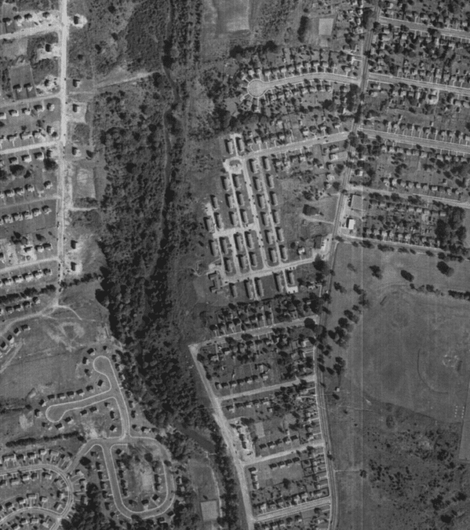
Section of Trout Brook Drive ending at Dartmouth Avenue in this aerial view from 1951.
What would the original advocates of the Trout Brook parkway make of all of this development? Would they be upset that it has taken so long and is still a work in progress almost 110 years later? Or would there be a sense of relief that we still care enough to keep going?
The popularity of automobiles in the 1920s made the idea of a Trout Brook Drive entirely compatible with appreciating nature. Today, our priorities have changed and trended more towards a walking and biking trail along the brook. It has been 15 years since the trail started, but compared to the rest of its history, this is quite a short time. The only constant in the story of how we coexist with the brook – whether by running mills, enjoying the leisure of its current, clashing against its moody temperament, or zooming alongside its contours – is that it remains a vital lifeline in the town of West Hartford.
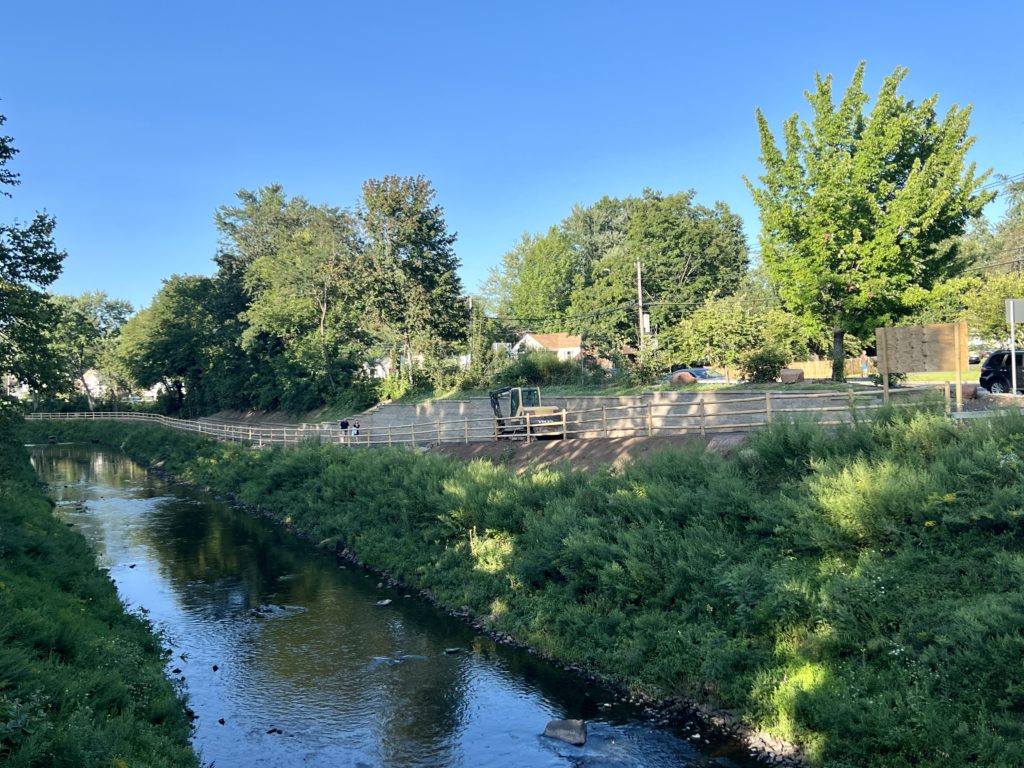
The section of the Trout Brook Trail while under construction from Fern Street to Duffield Drive in August 2023. Photo credit: Ronni Newton (we-ha.com file photo)
Jeff Murray was born and raised in West Hartford and has been involved with the Noah Webster House & West Hartford Historical Society since 2011 when he was a high school student and won the Meyer Prize for his essay on local history. Jeff routinely volunteers as local history researcher uncovering information for numerous museum programs such as the West Hartford House Tour and West Hartford Hauntings. Jeff works as a data analyst at Pratt & Whitney.
Like what you see here? Click here to subscribe to We-Ha’s newsletter so you’ll always be in the know about what’s happening in West Hartford! Click the blue button below to become a supporter of We-Ha.com and our efforts to continue producing quality journalism.


So, Trout Brook used to be the Noyes River until sometime in the 1870’s?
And the other “enquiring minds want to know” question is, of course, has anyone seen an actual trout in Trout Brook recently?
This link is a great old film of cow wrangling in Trout Brook by members of the AC Peterson family in the 1930s
https://www.youtube.com/watch?v=5n-0fiO4cWc
Oh my! Thank-you for the link! And thanks to Ray for posting these home movies on youtube.