
West Hartford’s ‘Thursday Throwback’

Audio By Carbonatix

Courtesy Noah Webster House & West Hartford Historical Society
Test your knowledge of West Hartford history with this ‘Thursday Throwback,’ courtesy of the Noah Webster House and West Hartford Historical Society.
By Ronni Newton
It’s time to take a look back into West Hartford’s past to either stir up some memories, reflect on how much things have changed, or both. And if you have no idea, we love the photo captions, too!
I was on a pretty good roll with posting Throwback Thursday images every week, and I’m very sorry for missing last week.
Courtesy Noah Webster House & West Hartford Historical Society
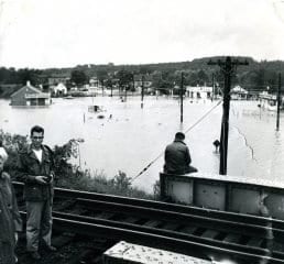
I shared a photo two weeks ago (at right and in larger size below) that seemed quite appropriate because it was a scene of flooding and it seemed like every day that week had been rainy. That weather seems to have continued, but at least the drought has lessened!
I figured that there would be a good number of readers who could figure out where the photo was taken, even if they didn’t recall the scene firsthand, and that proved true.
Robert Farr was the first to comment: “The only rail bridge over a road I know of that looks like this is at the corner of New Park and New Britain Aves. Looking down New Britain Ave. towards Hartford; South St. under there somewhere on the right. There’s a shopping plaza now behind where the gas station is here, with the wonderful A Dong market. Probably August of 1955.”
Dianne Rechel agreed: “The only trestle bridge that comes to mind is over New Britain Ave. The flood of ’55? But where did all that water come from- did Trout Brook reach that far? The brick building on the left looks like Lincoln Dairy, later replaced by a behemoth. Loved their chocolate chip ice cream!”
“Isn’t Piper Brook in that area? Before flood control there was lots of temporary flooding, but this is really deep,” added Liz Gillette.
Aaron Picker wrote: “My father says it’s the location that everyone correctly recognizes, but that due to the partially submerged panel truck, it’s the aftermath of the Park River flooding that area due to the hurricane of ’38. I’d have guessed the same as everyone else since the location is clear but the only flood photos like that I’ve seen were from the ’55 flood (but in Winchester County),” but Aaron said based on the clothing and the apparent vintage of that truck, he didn’t agree with his father and thought – correctly – that this photo was taken in 1955.
Many readers also added their comments on Facebook.
“That looks like the overpass on New Britain Ave looking back toward Hartford Lincoln Dairy on the left may be the clue. My guess is the flood of 1955,” commented David Dyson.
“Looking east down New Britain Ave., across what is now the busway,” wrote Beverly Truebig.
Paul Ericson had firsthand knowledge: “I’m thinking view looking from RR bridge at New Park Avenue and New Britain Avenue looking towards Hartford. Remember the event quite well.”
Alice Wilson Slingerland also had a vivid memory of this time: “If it’s the flood it was 1955. I remember so clearly as we had helicopter rescue from Camp Shalom to a church in Bloomfield where we slept on pews. My only helicopter ride.”
Karen O’Maxfield added, “Used to go that Lincoln Dairy all the time. That, the RR tracks and Cedar Mountain gave it away for me.”
Michael Rioual said he used to put pennies on the tracks of that railroad bridge.
Others also remembered Lincoln Dairy. “They delivered milk to my home when I was a kid,” Cindy Rosenbluth wrote.
Thomas Newton had some more details, including about why this area doesn’t flood anymore. “Absolutely looking east down nba (US 6) maybe flood of 55?. Before the 72-74 widening of Trout and Piper Brooks under NBA near present day Dunkin Donuts. The two buildings across from Lincoln dairy are currently Chadrad motors and Car Craft auto body at the corner of South St. In the distance on the same side of nba is a building what was Oil Heat and Engineering later Empire Furniture.”
“The two buildings across from Lincoln dairy are currently Chadrad motors and Car Craft auto body at the corner of South St. In the distance on the same side of nba is a building what was Oil Heat and Engineering later Empire Furniture,” added Vittorio Buccilli. “My family’s station was further down across from Hillcrest, Newton’s Esso/Exxon 58-78,” added Thomas.
Rick Liftig had some more updates, including future plans for the railroad bridge: “Before the Trout Brook was placed in a concrete culvert (early 1960s), this was a yearly problem. And guess what – that good old railroad bridge is finally going to get painted by the DOT (if there is any money left for paint).”
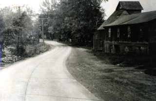
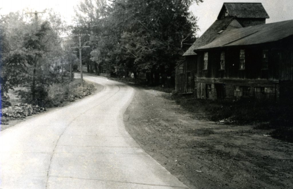
Courtesy Noah Webster House & West Hartford Historical Society
This week’s photo (at right and in larger size below as well as at the top of this column) could be a tough one.
Who knows where this photo was taken?
What is the building in the photo?
Does that building stand today and if so what is it used for?
When was this photo taken?
If you have memories, please share them below.
Thank you to the Noah Webster House & West Hartford Historical Society for providing us with the images. They are always looking for new images to add to the collection. Visit their website at www.noahwebsterhouse.org for more information about membership and programs.
Like what you see here? Click here to subscribe to We-Ha’s newsletter so you’ll always be in the know about what’s happening in West Hartford!
Courtesy Noah Webster House & West Hartford Historical Society
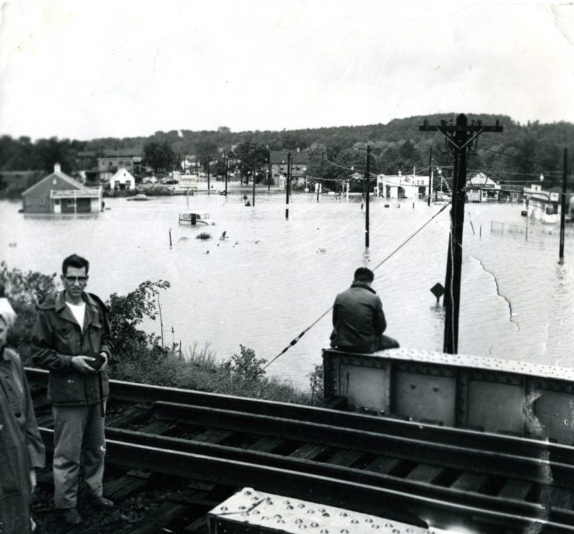
New Britain Avenue at New Park Avenue, looking east. 1955. Courtesy Noah Webster House & West Hartford Historical Society


I believe the West Hartford Art League now occupies the building, on Buena Vista Road
When I was in high school, in the sixties, I worked for parks and recreation and this building also served as the residence for one of the towns park superintendents.
I believe the West Hartford Art League on Buena Vista Road now occupies this building. When I was in high school in the early sixties I worked part time for the Parks and Recreation Department. The superintendent for the golf course lived in the house at the time
One more possibility could be part of the Beach farm property. That I don’t remember it’s just a guess and I don’t think there’s anyone alive today who would remember the location.