
West Hartford’s ‘Thursday Throwback’

Audio By Carbonatix

Courtesy Noah Webster House & West Hartford Historical Society
Test your knowledge of West Hartford history with this ‘Thursday Throwback,’ courtesy of the Noah Webster House and West Hartford Historical Society.
By Ronni Newton
It’s Throwback Thursday (#tbt), and time to take a look back into West Hartford’s past to either stir up some memories, reflect on how much things have changed, or both. And if you have no idea, we love the photo captions, too!

Courtesy Noah Webster House & West Hartford Historical Society
Although some of you thought last week’s image (at right and in larger size below) was too easy to identify, I personally had to do a drive-by to make sure everyone was correct because I thought there were several places that look pretty similar to the scene in this photo.
Rob Rowlson was the first to comment, and he got it right and also included some interesting details: “Farmington Ave. looking east towards Quaker Lane. The photo appears to have been taken from approximately the location of AAA. The apartments were constructed in the 20s, 30s and 40s along Farmington Ave. to provide housing for the ‘Aetna Girls.’ Many of these apartment buildings had little or no parking since they were on the trolley line.”
“Rob beat me to it and he covered the topic in spades. OTOH [on the other hand], he did post at 1:25 a.m.!” wrote Rick Liftig. In a comment on Facebook, Rick also wrote, “Those little architectural touches really define many of WH’s buildings and set them apart. Even if it is a faux style, it really adds to the street scape.”
Connie Reder, who also knew where this was but said not having power delayed her ability to comment, thought that this photo was a “throwback throwback” and either the identical photo or one similar was featured in this column a year or two ago. I wasn’t actually able to find that but if anyone has it, please email it to me at [email protected].
“Greg B.” also said Rob beat him to the answer that this photo is of the block across from the AAA building. “I’ve read that the AAA lot was a proposed site of a Sheraton hotel in the 1960s,” Greg added.
Town Historian Tracey Wilson also weighed in with her comments: “You all are very good — I was thinking at first it was the row of apartments across from Hampshire House – and that Farmington Ave. had sunk a bit since this photo which must be from the 1940s. The AAA building was built in 1966 and I do think there was talk of a hotel there. 814 Farmington Ave. was built in 1927 – the trolley still would have been running – I can’t tell if the trolley tracks are on the street hear? Can any of you?”
It does appear that there may be trolley tracks in the photo. Rob Rowlson said that remnants of trolly tracks were found along Farmington Avenue as well as on Park Road during reconstruction.
Gordon Reeder had some firsthand knowledge of this scene. “Well, everyone beat me to it. But, I recognized the place immediately. I used to deliver the Hartford Times to those buildings,” he commented.
One of the Facebook comments was from a former resident of one of the buildings in the photo. “Lived in a 1st floor apartment in the middle of the center building for a year. Called it the ‘gloom and doom’ apartment. It got very little natural light and had a painted stretched canvas ceiling. Happened to be tossing a small stress ball in the air one day and it hit the ceiling and rippled through the rest of the room. Great location,” wrote Denise Simetkosky Rocktaschel.
There were a number of other comments on Facebook as well, with most guessing correctly and a few saying this was a much too easy throwback Thursday. (It’s not always meant to be tricky!)
Courtesy Noah Webster House & West Hartford Historical Society
This week’s throwback image (at right and in larger size below) should be a bit more difficult to identify, but then again our readers are really sharp so some may get it right away.
Where was this photo taken?
Any idea when this photo was taken?
Can you identify anything that’s on this stretch of road today?
Please share your memories below.
Thank you to the Noah Webster House & West Hartford Historical Society for providing us with the images. They are always looking for new images to add to the collection. Visit their website atwww.noahwebsterhouse.orgfor more information about membership and programs.
Like what you see here? Click here to subscribe to We-Ha’s newsletter so you’ll always be in the know about what’s happening in West Hartford!
Courtesy Noah Webster House & West Hartford Historical Society
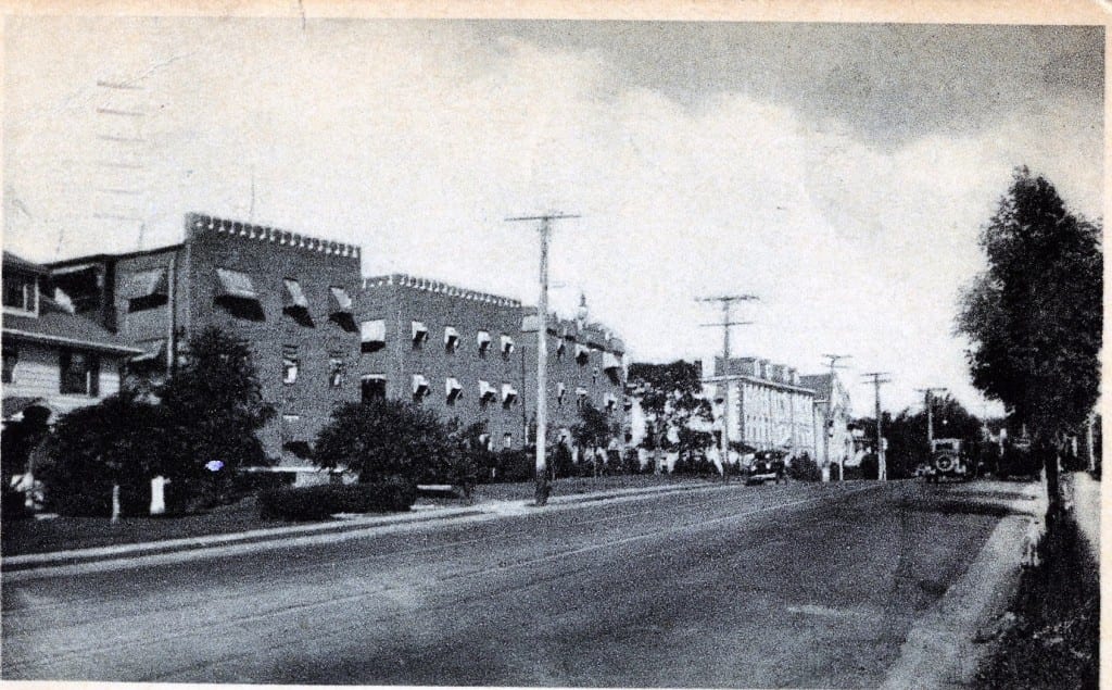
North side of Farmington Avenue looking east toward Quaker Lane. Courtesy Noah Webster House & West Hartford Historical Society

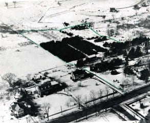
Wild guess coming your way. This is a really old picture. Foreground is New Park Avenue. Two large building in rear are chandler Evens (now colts). If correct then the top
Green line is likely to be Quaker Lane South.
Very difficult one this week.
I’m going to wild guess South Main looking west, just north of Rockledge and south of the Noah Webster House. I think the fields in the back will become the golf course. I think at least the two houses on the left hand side are still there. I have no idea what the green line would signify other than some sort of boundary.
This IS a tough one!
Liz is right. You can actually see the Noah Webster house on the very right (with a porch on the side!), and then to the left 235 South Main with it’s five windows in the front, and then 241 (the big brick one that’s all torn apart now). 235 was built in 1937, so the photo is at oldest from then. Behind them is now Pheasant Hill, which was built in the 1960’s
(Thanks, Mike. We’ll see if it is the right guess. But…it was actually my husband, Doug, who looked over my shoulder for a brief glance and said, “That’s Rockledge.” Then I saw it. But don’t tell…)