
West Hartford’s ‘Thursday Throwback’

Audio By Carbonatix

Courtesy Noah Webster House & West Hartford Historical Society
Test your knowledge of West Hartford history with this ‘Thursday Throwback,’ courtesy of the Noah Webster House and West Hartford Historical Society.
By Ronni Newton
It’s Throwback Thursday (#tbt), and time to take a look back into West Hartford’s past to either stir up some memories, reflect on how much things have changed, or both. And if you have no idea, we love the photo captions, too!
Courtesy Noah Webster House & West Hartford Historical Society
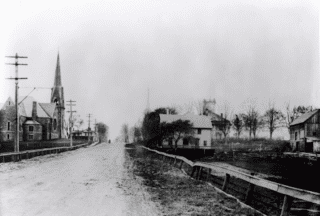
Last week’s photo (at right and in larger size below) was a throwback to the days before what looks to be one of the town’s main streets was paved. That made identifying the location rather difficult, even for our veteran local history buffs.
Rick Liftig was the first to comment: “I’ve got my guessing hat on. That sure looks like the Farmington Avenue Hill facing West. The church on the left would be where the Congregational Church is now (and is probably a previous incarnation) and the house on the right is the parking lot for Bank of America. But, there’s a utility pole with electricity and phone, but NO trolley tracks… so color me – confused.” He added a second comment: “One more thought: the church at the top of the hill to the right certainly resembles the Baptist Church on N. Main. Any chance that this was Fern St facing East?”
Liz Gillette said, “I’m going to piggy-back on Rick. I think it’s taken at about Troutbrook looking towards Main. The Congregational church was also called the “greystone church” and burned down in 1942. Is the square topped building way in the back right the old town hall on the northwest corner? If so that would make the steeple the old Baptist church (I think…) While it may be earlier, I wonder if this is a picture of the once famous West Hartford mud, perhaps covering the tracks. Do the utility poles have an arm on them that would be the trolley cable?”
Mike Margolis had another thought: “Is this New Britain Avenue looking west up the hill from about New Park? This is a tough one!”
Several readers added their comments on Facebook.
“I’ll take a stab, tho I’m a relative newcomer and hopefully get a pass accordingly. Is that new Britain Ave, with St. Brigid church? I’d guess early 20th century, given the electrical lines,” said Jennifer Cote.
Zachary Hilborn wrote: “Farmington avenue looking west towards west hartford center, we see the first church on the left, burned by a fire in 1947 and replaced with the current structure.” Nancy McClelland Ball agreeed: “Farmington Ave. east of South Main St. Congregational Church on the left corner (Greystone Church). Right corner is where the bank is today.”
The correct answer, according to the Noah Webster House & West Hartford Historical Society is … “Farmington Ave looking West approximately from Troutbrook.” I’m sorry to say there was not a year provided. I don’t see the trolley tracks either, and although I’m not sure what the “once famous West Hartford mud” it’s possible that the tracks are on the side of the road underneath the telephone/electric poles and are partially obscured. The visible church at the left is the “Greystone” church, the fourth building of the First Congregational Church. It was built in 1882 and destroyed by fire in 1942. The other steeple – barely visible in the center of the image – belongs to the Baptist Church and to its right is Town Hall, which at the time was located in First Church’s third building. According to the “Celebrate! West Hartford” book, where this image also appears (and where many of these details were found), the house visible in the image belonged to the Andrews family.
Courtesy Noah Webster House & West Hartford Historical Society
Some readers may remember when the buildings in this week’s image (at right and in larger size below) looked like this.
Where was this photo taken?
What year was this? (We have the correct answer available this week!)
What are some of the visible businesses?
What is in this location today?
Please share your memories below.
Thank you to the Noah Webster House & West Hartford Historical Society for providing us with the images. They are always looking for new images to add to the collection. Visit their website atwww.noahwebsterhouse.orgfor more information about membership and programs.
Like what you see here? Click here to subscribe to We-Ha’s newsletter so you’ll always be in the know about what’s happening in West Hartford!
Courtesy Noah Webster House & West Hartford Historical Society
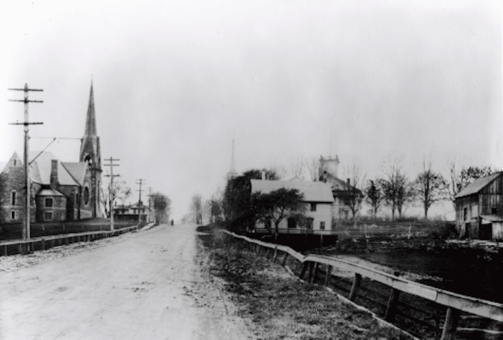
Farmington Avenue looking west toward South Main Street from Trout Brook Drive. Courtesy Noah Webster House & West Hartford Historical Society

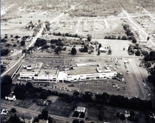
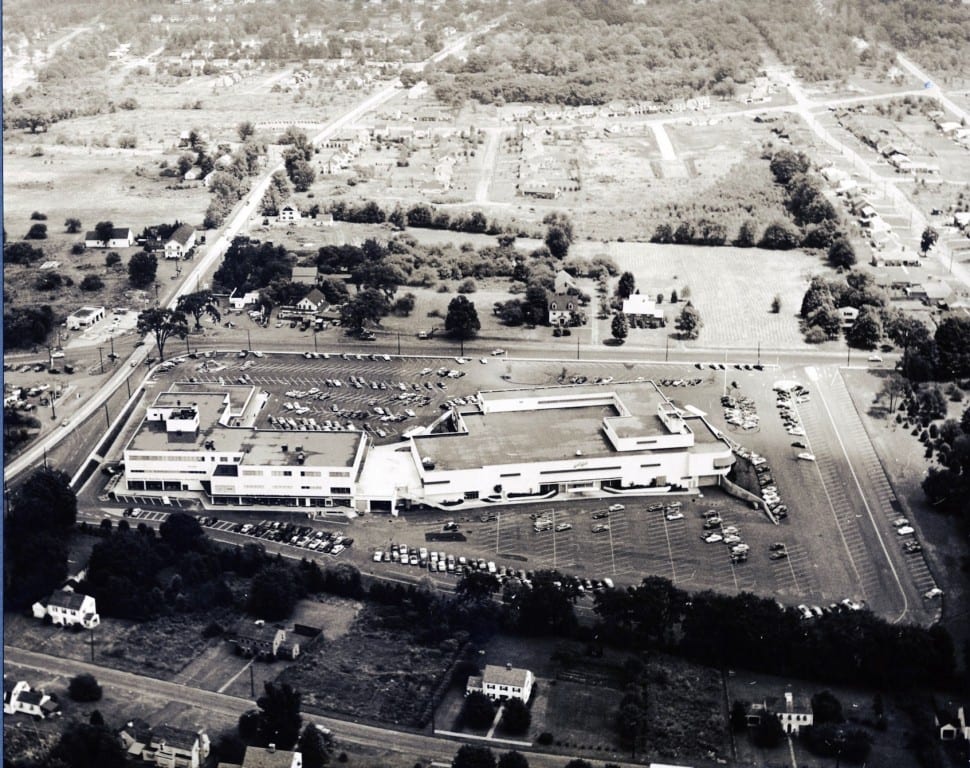
Bishop’s Corner – 345 North Main – maybe 1955-58. It’s amazing to see all of the open space in this photo!
That was one spiffy shopping center in its day: Lord and Taylor (replete with Fenway green awnings, S.S. Pierce Gourmet foods (does anyone else remember how their printed ads had a weird smell?), Doubleday Books, and to balance it off, FW Woolworth. Woolworth’s smelled of popcorn (used to lure you into eat) and had a million ceiling fans.
This was the Westfarms of its day – really the first suburban shopping mall in the area.
Bishops Corner from the air looking East with North Main on the other side. The S. S. Pierce store facing South, sold quality foods and provided gift packages that could be mailed, even to soldiers serving overseas. A forerunner of Whole Foods.
Oh, Lord and Taylor was so elegant! And yes, SS Pierce – the exotic asparagus in a can – in November, no less!
When I was little, and older woman named “Teddie” worked on the ground floor of Woolworth’s where the small pets were. She’d let you pet the hamsters. And escalators! The big time…
As to the date, when I was very little, my mother shopped at the Popular which is Crown today. I’d peg the picture at the lower end of the 55-58 range, perhaps right after it was built. Before that I believe it was Dutchman (?) Dairy. There was a windmill on top of the building that went on to become Gledhill Nursery’s logo.
Over the years, Caldor’s, Pottery Shed, Metzger’s, the original Bookworm, Harvey & Lewis, Linen’s and Things, and my favorite memory – Debbie Reynold’s Slimming Studio!
We can date this photo to somewhere between 1950 and 1957.
77 Blue Ridge was built in 1950, that is shown
62 Blue Ridge is not in the photo, that was built in 1957
All the houses showing on Blue Ridge were built between 1942 and 1950
Haynes Road was mostly built in 1948 and 1949, but there’s not enough detail to show which house is which.
Darn it, my house is there but obscured by trees!
Silly me, I never looked at the shopping center, which was built in 1953 and 1954. So we can date the photo to somewhere from 1954 to 1957