
Road Diet Study for West Hartford’s North Main Street Begins Phase 2, Public Input Invited

Audio By Carbonatix

Snapshot of road diet configuration on North Main Street in the area of Brookside Boulevard. Courtesy of VHB
A public information meeting will be held on Thursday, April 29, and the public is also invited to provide feedback via an online survey.
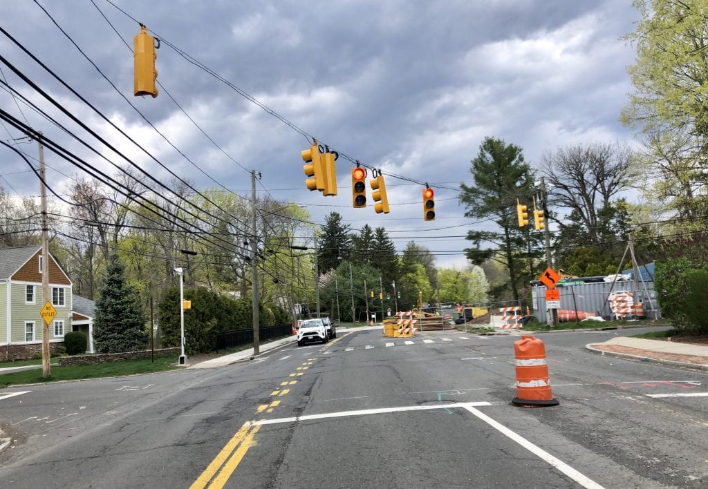
North Main Street looking north at Linbrook Road, where work on the bridge has been underway since early 2020. Photo credit: Ronni Newton
By Ronni Newton
A section of North Main Street in West Hartford has been reduced to one lane in each direction while bridge construction is underway, and as soon as that project is completed – which will likely be this summer – a six-month road diet trial phase will get underway.
The town is looking for the public’s input through a survey (click here to access) and in conjunction with Vanasse Hangen Brustlin, Inc. (VHB), the project design consultant, will conduct a public information meeting regarding implementation of the trial phase. That meeting will take place on Thursday, April 29, 2021, beginning at 6 p.m. via Zoom (link details can be found below).
The proposed road diet will impact North Main Street from Farmington Avenue through Albany Avenue, and will involve a reduction in the number of travel lanes from four (two in each direction north and southbound) to one 10-foot-wide travel lane in each direction and a 12-foot-wide center turning lane along the length of the roadway.
“In some areas where [the roadway] is 42 feet wide there is enough room for a 5-foot shoulder,” said Greg Sommer, West Hartford’s assistant town engineer.
The shoulder area won’t be an official bike lane, but can be used by cyclists.
On the sectional of roadway from Loomis Drive north to Fern Street, the roadway is only 40 feet wide, and for the trial will be striped with a 5-foot-wide shoulder on the southbound side and a 3-foot-wide shoulder on the northbound side, Sommer said.
The PDF attached below illustrates the lane configuration of each segment of the stretch of roadway.
Joe Balskus, director of Transportation Systems for VHB, which is serving as project manager, said as part of the Phase 2 study, his firm will review the potential impacts of the road diet on Trout Brook Drive and Mountain Road – the other major north-south roadways in the area – in addition to North Main Street.
“VHB’s scope of work is the conduct an extensive monitoring program of the road diet trial over the six months of implementation and based upon several factors, provide a recommendation to the town to continue, discontinue and/or provide recommendations to address the speeds and crash history on North Main Street,” Balskus told We-Ha.com in an email. He said the trial will be evaluated according to at least the following nine factors (and not necessarily in this order):
- Crash frequency and severity
- Emergency vehicle accessibility/response time
- Pedestrian and bicyclist usage and safety
- Intersection or roadway segment congestion
- Neighborhood traffic safety issues
- Travel time runs results
- Traffic queue measurements
- Intersection/driveway accessibility
- Public feedback (summarized survey results)
Sommer said that if the road diet trial proves successful and the town decides the reconfiguration will become permanent, it will be possible to increase the width of the shoulder on the northbound Loomis-to-Fern stretch by relocating the curbing and driveway cutouts so that shoulder will also be 5 feet and able to be used by bicyclists. There will not need to be a right-of -way acquisition, relocation of the sidewalk would not be needed, and all of the utility poles are already on the other side of the roadway and would not be impacted either, Sommer said.

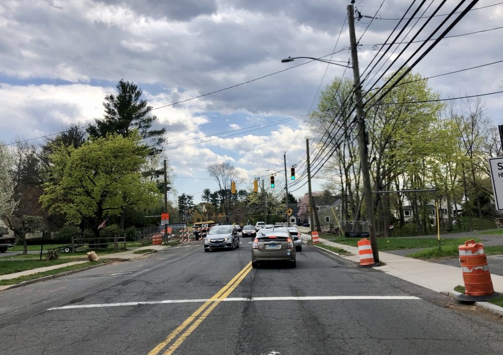
North Main Street looking south from Wyndwood Road. Photo credit: Ronni Newton
The concept of a road diet for North Main Street, between Farmington Avenue and Albany Avenue, has been under discussion for many years as a means of improving safety for motorists as well as pedestrians and bicyclists, and efforts began in earnest with a study conducted by the Capital Region Council of Governments (CRCOG) in 2015.
Following the completion of the grant-funded study, a draft report was presented by CRCOG to the town in June 2016. Four different options for a road diet were presented along with several possible add-ons, with the most basic – and least costly – option including re-striping of a portion of the existing roadway so that there would be one travel lane in either direction, and a turning lane in the middle, with with an increase in the width of the shoulders that could accommodate bicycles and keep vehicles farther away from the sidewalks.
Many residents of the North Main Street area had been advocating for the road diet trial to begin immediately following the bridge work, since the lanes have been restricted anyway, and in January 2019 the Town Council’s Community Planning and Physical Services Committee gave consensus approval for it to move forward.
North Main Street looking south where work on the bridge has been underway since early 2020. Photo credit: Ronni Newton
Rehabilitation of the the North Main Street bridge, for which funding was delayed by the state several times, began in January 2020 and is scheduled to be completed by the summer of 2021. The original North Main Street bridge over Trout Brook West Branch just north of Wyndwood Road was built in 1901 and had been classified as “poor” by the state Department of Transportation.
More information about the road diet, phases of the plan, project documents, and the link to the survey is available on the project web page on the town’s website. Comments from the public can also be made to VHB by calling 860-807-4405.
The public informational meeting is being held to afford a full opportunity for public participation and to allow open discussion of any views and comments the community may have concerning this proposed road diet trial implementation. The meeting can be accessed by clicking the link below and entering passcode: 689099.
https://vhb.zoom.us/j/96315814557?pwd=ckE5UEVta0pjb25wSmpqUnp1OHpPdz09
Individuals with limited internet access can listen to the meeting by calling 1-301-715-8592 and entering the Participant Code when prompted: 963 1581 4557. Hardcopies of the meeting materials can be requested by contacting by the project consultant, VHB at 860-807-4405 (Allow one week for processing and delivery). A recording of the formal presentation will be live streamed and posted to YouTube following the event and closed-captioning (including non-English translation options) will be available at that time.
Like what you see here? Click here to subscribe to We-Ha’s newsletter so you’ll always be in the know about what’s happening in West Hartford! Click the blue button below to become a supporter of We-Ha.com and our efforts to continue producing quality journalism.
 Loading...

Are you people nuts? This is the stupidest idea since back in parking on Lasalle. This will fail the first week. Who the hell is responsible so heads can politically roll when this waste of time and money ends. And remember our side streets in West Hartford Center where I live will become a damn nightmare worse than they are for cut throughs. West Hartford where city style meets village idiots !!!
I am hoping they can be persuaded to keep the light at North Main and Linbrook/Wyndwood Roads. If not, at least with a 5 foot buffer one might be able to take a right turn on North Main without getting wiped out by folks speeding in my neighborhood in excess of 50 mph. As an experiment try driving the speed limit between the Center and Bishops Corner. See how much traffic and drivers will fly by you. I think this will make folks slow down and with the turning lanes be less afraid of being rear-ended making turns into our side streets. Plus that will keep the traffic flow going. Currently anyone taking a left turn backs up traffic. That presumes that folks now how to use a center turn lane properly. I also look forward to riding my bike between Bishops Corner and the Center shopping districts. In my time here there have been many accidents at North Main and Asylum and also several car to telephone pole collisions caused by the narrow roadway with four lanes. I remember when Farmington Avenue was four lanes out to the Stop and Shop. The current design is an improvement in aesthetics and in driving functionality. I am willing to give the experiment a chance.