
DEEP Responds to West Hartford Residents, But Anger and Distrust Persist

Audio By Carbonatix

Many residents of the Horseshoe neighborhood arrived at Town Hall Wednesday evening wearing these t-shirts. Photo credit: Ronni Newton
More than 100 people attended a DEEP public information session Wednesday evening at West Hartford Town Hall, and although numerous issues were addressed, there is still much skepticism and frustration.
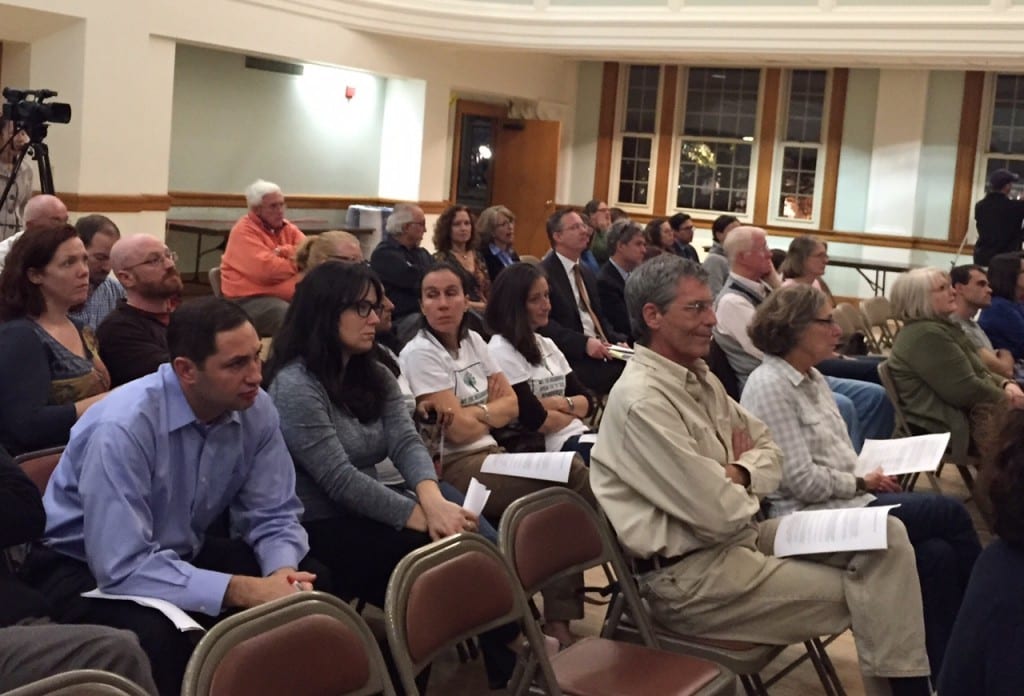
More than 100 people attended a public information session with the DEEP at West Harford Town Hall on Nov. 4. Photo credit: Ronni Newton
By Ronni Newton
Officials from the Connecticut Department of Energy and Environmental Protection (DEEP) and other flood control management experts arrived at West Hartford Town Hall Wednesday evening with an agenda that included plans for a 45-minute PowerPoint presentation followed by breakout sections for neighborhoods impacted by the work on the South Branch of the Park River, but within a few minutes irate residents forced the scrapping of the agenda and turned the evening into an opportunity for venting and questioning.
“I know we got off to the wrong foot and I apologized last week for the lack of outreach. That was really dropping the ball on our part. We did stop work for two weeks so we could make a fresh start, and other than one rogue subcontractor [that violated the stop-work order and was let go] … I believe we did our best,” DEEP Commissioner Robert Klee said in his opening remarks to the audience.
Klee, who had angered residents at last week’s Town Council meeting when he admitted that he had not been to the Linbrook and Linnard road area where clearcutting had taken place, said that he had now walked the entire 11-mile length of the project work area. He reiterated to residents the need to perform intensive maintenance of the flood control channel, “get it done right, get it done safely so that your families are protected and your property is not threatened by flood waters.”
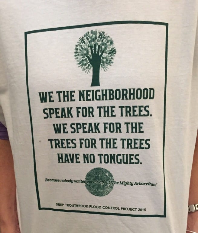
Many residents of the Horseshoe neighborhood arrived at Town Hall Wednesday evening wearing these t-shirts. Photo credit: Ronni Newton
West Hartford residents, particularly those in the “Horseshoe” neighborhood that includes Linbrook and Linnard roads, say they agree that they want the channel to work properly. What they object to is the way the state has gone about the project and the lack of communication and accurate information.
The residents did not want to sit through a PowerPoint presentation about the history of flooding in West Hartford; they wanted answers and wasted no time interrupting presentations to insist that their concerns and questions be addressed.
“You don’t get to stand at the podium all night and say your side make us go into small groups and not let us ask questions,” one man said, interrupting Bureau Chief Betsey Wingfield of DEEP’s Bureau of Water Protecton and Land Reuse, who was explaining how the DEEP is organized, how the dam safety program functions, and outlining what information about the project has now been posted on the DEEP website.
“I think the point is that we would like to be in this together,” said another resident. After a show of hands in the audience indicated that there was only one resident from the “south” section of the project (South Quaker Lane to Southwood Drive), one from the “central” section (Memorial Road to South Quaker Lane), and about 100 from the “north,” the DEEP agreed to allow the discussion to remain in the Town Hall Auditorium rather than breaking into separate groups.
State Conservation Engineer Arde Ranthum, who was trying to explain the history and mission of the Natural Resouces Conservation Service (NRCS), was forced to sit down after residents angrily protested that they were being filibustered.
“I really don’t see how this is germane. It’s like the patient’s on the operating table waiting to get cut open and you’re explaining how the hospital’s service is and how the hospital was developed. All this can be accessible through a website,” said Linbrook Road resident Art Bourgault. “I think the people came here tonight to engage you, to find out how the process is going to take place, and what the plan is,” Bourgault said, followed by a round of applause from the audience.
DEEP Supervising Environmental Analyst Jennifer Perry took over the podium, insisting that the audience listen to a portion of the presentation, which she said would address many of the questions raised at the Oct. 27 Town Council meeting and in a letter sent over the weekend by Town Manager Ron Van Winkle.
“It’s important you understand that the system was put in to protect your homes. You’re all invested and we understand that. Why are we doing this scale of maintenance now? It’s been 15 years since this was done – 15 years of inadequate maintenance of this channel,” Perry said. NRCS has said this needs to be done or will it will decertify the channel, she said.
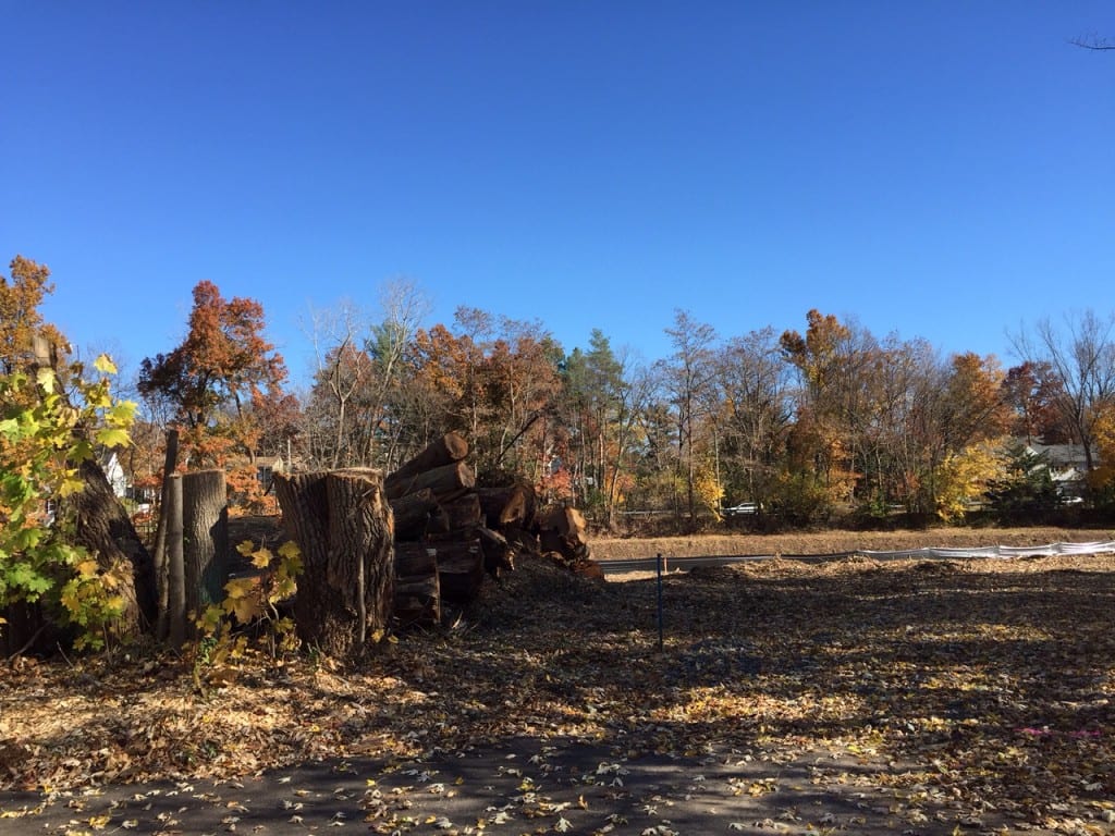
Area at the end of Linbrook Road, Nov. 3, 2015. Only a few trees, stumps, and some cut lumber remain. Photo credit: Ronni Newton
Perry was interrupted with a question from the audience about whether the same number of trees would have been cut down had the area been properly maintained. “Some would have had to have been cut down. To some extent it would have been less disruptive,” she said.
Planning for the project began in 2010, and an extension has already been requested. Perry said that talks have been held with town officials throughout the duration. “This is a huge project … about 2,500 dump trucks worth of material that needs to be dredged out of these channels,” Perry said.
“DEEP is trying to throw this back at us,” Van Winkle said Thursday in response to insinuations that West Hartford officials knew all along what the project entailed, failed to communicate it to residents, and is at fault for not properly keeping the area clear of vegetation. “We have no responsibility to maintain it. It’s not our property.”
Van Winkle said that although he did not know that the area would be clearcut until it happened, when he realized that the scope of the project would be extremely large, in July 2015, he asked the state to do outreach and they said, ‘We don’t do this.'” He wrote a letter dated July 21, 2015, telling the commissioner to do “meaningful outreach.” Van Winkle said that they: “A: Did not respond; and B: Did not do it.”
“We have some culpability. Maybe we should have pushed this to the governor’s office or involved our state legislators, but we don’t usually do that. In hindsight it would have been better to do that,” Van Winkle said.
Perry outlined the DEEP’s response to many of the issues raised by Van Winkle in an email sent last weekend, as well as questions sent in a letter from resident Suzanne Kinard.
Information specific to the project can now be found on a dedicated page on the DEEP website www.ct.gov/deep/sbpr. Trees to be cut down in the future, and there will be more she said, will be marked. The sites will be secured. Truck traffic will be restricted to 9 a.m. through 3 p.m. There will be an inspector assigned to the job and the streets will be swept as needed. A licensed arborist will be on call.
“No hazardous material being dredged out of any of these channels,” Perry said in response to a concern about the sediment being removed. However, additional testing on the material is being done and results are not yet available, she said.
As for the request to leave a 20-foot buffer between all residential properties, “We can’t do it. There isn’t always 20 feet,” Perry said. Trees and vegetation must be kept out of the floodway, she said.
Horseshoe neighborhood residents had earlier asked if contractors were profiting from the removal of extra trees, particularly hardwoods. “The contractor isn’t making additional money by clearing additional trees. No trees are being cleared without our approval,” Perry said.
Montclair Drive resident Jim Henkel later asked for clarification about how well the message about which trees could be cut is being relayed to the subcontractors. He said there had been nine red oak trees in the area at the end of Linbrook that had been identified with blue numbers. “[DEEP Project Manager] Dan [Biron] said all the trees had to come out except for 1 and 2 which could stay, but they took them anyway. I heard that was a mistake,” Henkel said. No. 1 and 2 was actually a double red oak, which residents had called the “kissing tree.”
“Was that just a mistake?” Henkel asked. “Unfortunately yes it was,” responded Biron, who added that the company taht removed the tree “is no longer on the project.”
Perry said that the total amount of material that needs to be removed from area at the end of Linbrook and Linnard is about 5,500 cubic yards of material. It will take 500 dump truck loads to remove it. Although she said that there will be a plan to restore the access and staging areas where clearcutting took place, the floodway and flood channel can be grassy but cannot have trees.
Approximately 20 residents asked questions or made statements throughout the session, which lasted about three hours. Some of the most pointed questions and statements came at the end of the night, after earlier responses had been digested and frustrations remained.
Linnard Road resident Paul Palmer, who lives right next to the area that has been clearcut, said that Biron admitted that the maps posted on the DEEP website prior to Wednesday were not properly marked to indicate that anything more than type one vegetation was to be removed from the end of his street. “Now we’re supposed to just trust you?” Palmer asked. “If you can mark this on two maps and then change it from nothing to access and staging?”
“I apologize if you think we were intentionally trying to hide something. I apologize that labeling was not changed,” Perry said. “I understand your frustration.”
“No you don’t live there, so you don’t,” replied Palmer, who said he also did receive any letter informing him in advance of tree removal. “Can I get an answer other than ‘Oops’? That’s a pretty big oversight. A company that we don’t employ anymore forgot to put it on map? It’s not a small point that it’s incorrect,” said Palmer.
“If someone was doing this in your neighborhood you wuldn’t be so relaxed. You were wrong, you told us to look at maps and they were wrong. What’s next?” asked Palmer. DEEP representatives did not respond.
Town Council member Chris Barnes, who has done extensive research and asked many targeted questions during last week’s Town Council meeting, said that the Environmental Protection Plan (EPP) that had been posted on the website showed what was to be the work area. “The map, that’s going to be posted on the website tomorrow, shows for the first time as part of the EPP there’s a place called ‘soil stockpile dewatering area.’ I find it amazing that you can’t explain to the folks in this room by relying on your own documents,” Barnes said. “I think it’s been made clear that the trees that were removed are not in the flood control area, they’re for the stockpiling. There were alternatives. It could have been done on other side of road in stages,” Barnes said. Mature trees were removed so that an area could be used for “a four-month time period to expedite this project. You have your own documents, they’re right here. Why not just show them?” Barnes said.
Van Winkle said he’s still frustrated after Wednesday evening’s session. “I’m not sure we got a lot of answers to our questions. They responded but did not say ‘We will agree.'”
DEEP said they would mark trees that are going to be cut down going forward, but he isn’t sure how the plan for what will happen after that will unfold. People in other neighborhoods which will soon be impacted won’t know what the marked trees mean unless there is meaningful outreach, he said.
“Nobody came [to Wednesday night’s information session] from the other neighborhoods. Why? Because they didn’t know about it,” Van Winkle said. Other than a press release, and articles in local press, downstream residents may not realize that this project will impact them directly. There are plans posted now that show type 2 vegetation – that includes trees – will be removed behind homes on Raymond Road that back up to Trout Brook. There’s also an area right behind homes along Overbrook and along Trout Brook Drive near I-84, Van Winkle said.
There has been one meeting, primarily attended by people from one neighborhood who were there because all the trees have been torn down, Van Winkle said. “I said to [DEEP officials] last night, and they weren’t very welcoming, that they need to first mark the trees and then send residents a letter telling them.”
Going forward, the Town will be following up to make sure the affected residents understand, Van Winkle said.
“The residents are right. This is our town,” he said. “We can at least make sure they know what’s happening, assuming the state lets me know, and I don’t have a lot of confidence.”
“Can we expect DEEP to operate as we expect them to operate? I’m not sure,” Van Winkle said.
Like what you see here? Click here to subscribe to We-Ha’s newsletter so you’ll always be in the know about what’s happening in West Hartford!


[…] DEEP Responds to West Hartford Residents, But Anger and Distrust Persist […]
Most of the soil and tree debris that has been washing into the flood control area near Linbrook Road for the past thirty years has come from the banks of the Trout Brook section that flows behind the properties on Montclair Drive. If the original flood control project had shored up the banks of those properties with rip rap (rock piles) at the start, most of this time and money spent on remediation would be unnecessary. Rip rap reinforcement was offered to those brook property owners, at cost, at the time of the first Trout Brook flood control project, but the high amount of bank erosion that has occurred was not foreseen at the time, so very few home owners paid to take advantage of the offer of reinforcement.
Because the Town of West Hartford did a pretty good job of keeping the site of the original flood control project clear of significant plant growth, I don’t believe that any of the trees cleared for this latest project had anything to do with flood prevention, contrary to what the DEEP is now telling residents. It seems clear that a contractor worked out how much open square footage would be needed to spread out 500 truckfuls of soil for “drying,” and that’s what determined the size of the area cleared of trees along the brook. Those cleared trees had been doing a good job of holding the river banks in place through years of recreational use of the pathways along the brook. And they also limited the noise pollution coming from Trout Brook Drive. A bunch of arborvitae or whatever else the DEEP decides to plant there when all is done won’t be nearly as effective.