
North Main Street Road Diet Trial in West Hartford to Begin the Week of August 9

Audio By Carbonatix

Message sign on North Main Street near Loomis indicates the start of the road diet trial. Courtesy photo
Crews will begin changing pavement markings on Monday, Aug. 9, with the goal of the road diet trial officially beginning on Friday, Aug. 13.
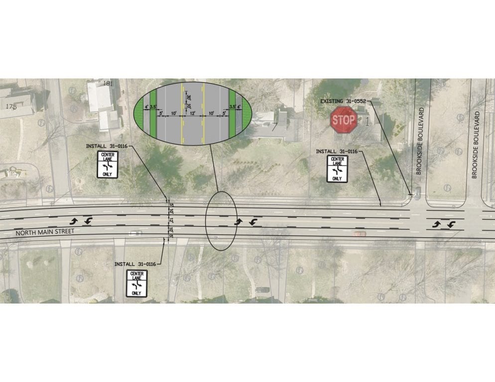
Snapshot of road diet configuration on North Main Street in the area of Brookside Boulevard. Courtesy of VHB
By Ronni Newton
The trial phase of the North Main Street road diet in West Hartford will become reality the week of Aug. 9, with new traffic patterns in effect by Friday, Aug. 13 that are scheduled to remain for roughly six months.
“The road diet was originally planned to start in July but we needed to wait for the [North Main Street] bridge work to be substantially complete, and that work will be wrapping up,” Assistant Town Engineer Greg Sommer told We-Ha.com. While there may still be some ongoing minor construction work on the bridge for a few days after the road diet begins, he said it will be limited to the shoulder area and should not impede the start of the trial.
According to Sommer, the existing pavement markings will be removed beginning Monday, Aug. 9, and then the new striping will be painted on the roadway. The painting work will be done overnight, he said, and weather permitting everything should be ready for the road diet trial to be operational by Friday.
Message signs are now in place on North Main Street just north of Loomis and just south of the entrance to the Bishops Corner shopping center where Target is located, alerting motorists about the upcoming changes in traffic patterns.
The road diet will impact the section of North Main Street from just north of Farmington Avenue at Loomis Drive through just south of Albany Avenue at Pioneer Drive, and will involve a reduction in the number of travel lanes from four (two in each direction north and southbound) to one 10-foot-wide travel lane in each direction and a 12-foot-wide center turning lane along the length of the roadway.
On the sectional of roadway from Loomis Drive north to Fern Street, the roadway is only 40 feet wide, and for the trial will be striped with a 5-foot-wide shoulder on the southbound side and a 3-foot-wide shoulder on the northbound side. The narrow shoulder area will not be wide enough to be safely used by cyclists, but the possibility exists for widening the shoulder if the road diet becomes permanent.
As the trial begins, new traffic signage will be installed and the traffic signals at the North Main Street intersections with Fern Street and Asylum Avenue will also be modified to include left turn arrows for northbound traffic.
The temporary traffic signals that have been in place during the bridge rehabilitation project will no longer be in use, the temporary crosswalks at Linbrook and Wyndwood will be removed, and the sidewalks will be fully reopened on both sides of North Main Street by the time the road diet begins.
The purpose of this upcoming trial is to evaluate traffic operations with the road diet concept in place to determine its effectiveness. “Unless it really falls apart,” Sommer said, the trial should last roughly six months – or until winter ends and the roadway markings are able to be modified again.
The town wanted to have the trial during the summer when traffic tends to be lighter.
“We wanted people to have a little time to get adjusted and used to it. When school starts, that will be the true test,” said Sommer.
During the road diet, traffic will be monitored not only on North Main Street, but also on Mountain Road and Trout Brook Drive – alternative routes that drivers may use to avoid any possible bottlenecks – as well as on various adjacent side streets that could be impacted by traffic being diverted.
Consulting firm Vanasse Hangen Brustlin, Inc. (VHB) has been engaged to assist with the project and will be monitoring traffic and collecting data.
Joe Balskus, director of Transportation Systems for VHB, previously told We-Ha.com that the trial will be evaluated according to at least the following nine factors (and not necessarily in this order):
- Crash frequency and severity
- Emergency vehicle accessibility/response time
- Pedestrian and bicyclist usage and safety
- Intersection or roadway segment congestion
- Neighborhood traffic safety issues
- Travel time runs results
- Traffic queue measurements
- Intersection/driveway accessibility
- Public feedback (summarized survey results)
During and following the trial phase, public feedback will be encouraged and a survey will be distributed to the community. More information can be found on the project website, www.westhartfordct.gov/roaddiet, and comments can also be shared with the project consultant VHB at 860-807-4405 or by emailing the project team at [email protected].
Sommer said previously that if the road diet trial proves successful and the town decides the reconfiguration will become permanent, it will be possible to increase the width of the shoulder on the northbound Loomis-to-Fern stretch by relocating the curbing and driveway cutouts so that shoulder will also be 5 feet and able to be used by bicyclists. There will not need to be a right-of -way acquisition, relocation of the sidewalk would not be needed, and all of the utility poles are already on the other side of the roadway and would not be impacted either.
The concept of a road diet for North Main Street, between Farmington Avenue and Albany Avenue, has been under discussion for many years as a means of improving safety for motorists as well as pedestrians and bicyclists, and efforts began in earnest with a study conducted by the Capital Region Council of Governments (CRCOG) in 2015.
Following the completion of the grant-funded study, a draft report was presented by CRCOG to the town in June 2016. Four different options for a road diet were presented along with several possible add-ons, with the most basic – and least costly – option including re-striping of a portion of the existing roadway so that there would be one travel lane in either direction, and a turning lane in the middle, with with an increase in the width of the shoulders that could accommodate bicycles and keep vehicles farther away from the sidewalks.
Many residents of the North Main Street area had been advocating for the road diet trial to begin immediately following the bridge work, since the lanes have been restricted anyway, and in January 2019 the Town Council’s Community Planning and Physical Services Committee gave consensus approval for it to move forward.
Like what you see here? Click here to subscribe to We-Ha’s newsletter so you’ll always be in the know about what’s happening in West Hartford! Click the blue button below to become a supporter of We-Ha.com and our efforts to continue producing quality journalism.


Can’t help but wonder if this money couldn’t be put to better use on some of WH’s bomb cratered, sunken, poorly patched and undermined roads. South Quaker is a dream to drive on, for one example.
Won’t reducing traffic lanes on North Main St. back up and congest traffic flow even more than it already is? I can’t see how this makes any sense, it’s like what was done to LaSalle Rd. Whose bright idea was this?
Let me get this right. The Democrats can’t help themselves in adding new apartment buildings all over thus greatly increasing our town (is it really a town?) population. We have 4 main North/South routes to cross our town; Prospect, Trout Brook, North Main and Mountain with Mountain being the only one that is not infested with red lights that are not coordinated. Our solution is to bottle neck one of them. What a great idea! Here’s one, why don’t you widen them with all that new infrastructure money we are getting from uncle Joe (and thus, mortgaging our great grandchildren). Do you think the traffic is simply going to go away? Now we will need to use more gas to go around? Really?
Moved back to West Hartford three years ago, after being away 20 years, and have been shocked by the deplorable condition of the roads! What gives? You can’t go from here to there without traffic galore, beggars at intersections, and potholes. And you even get to pay for parking in the center of town! How lucky are we!